


The surprise revelation means 12 million Vietnamese may need to retreat
By Charles Schmidt on August 28, 2019
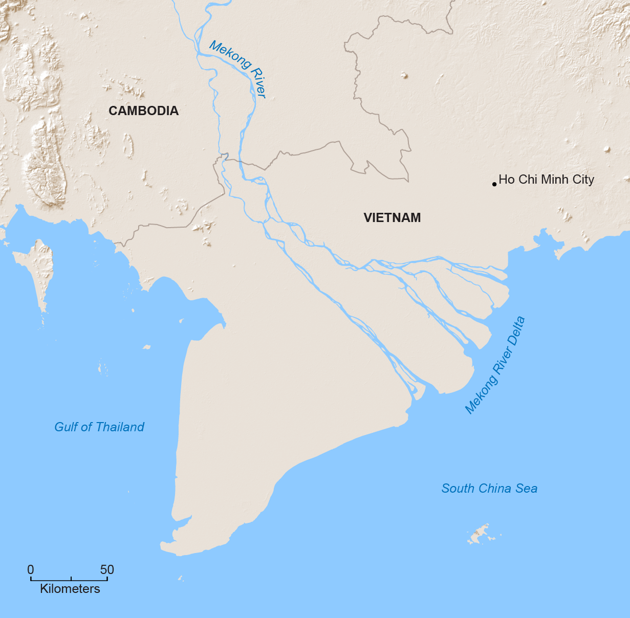
A stunning 12 million people could be displaced by flooding in Vietnam’s Mekong Delta within half a century, according to new research led by Philip Minderhoud, a geographer at Utrecht University in the Netherlands. Minderhoud and his colleagues arrived at that surprising conclusion after analyzing ground-based measurements of the Mekong’s topography that the Vietnamese government shielded from Western scientists for years. The results, published today in Nature Communications, show the Mekong’s elevation over sea level averages just 0.8 meter, which is almost two meters lower than commonly quoted estimates based on freely available satellite data.
The ground-truthed projection more than doubles the number of Vietnamese living in low-lying areas that will be inundated by encroaching seas, with some underwater in only a few decades. And Torbjörn E. Törnqvist, a geologist at Tulane University, who was not involved with the study, says the implications extend beyond the Mekong to similarly threatened deltas throughout the developing world. “My hope is that these findings will wake people up to the fact that we’re dealing with terrible data sets that aren’t appropriate for the problems these deltas are facing,” he says.
In many developing countries, elevation levels are derived from global satellite data because there are few ground-based measurements or because governments guard their own measurements from outside scientists. But satellite data can be notoriously unreliable for assessing vertical elevations in low-lying areas. According to Törnqvist, inaccurate topography data hamstring efforts to predict how soon portions of a given delta might fall below sea level. He says the problem is a concern not just for the Mekong but also for other mega deltas inhabited by tens of millions of people, including the Ganges in Bangladesh and India and the Irrawaddy in Myanmar.
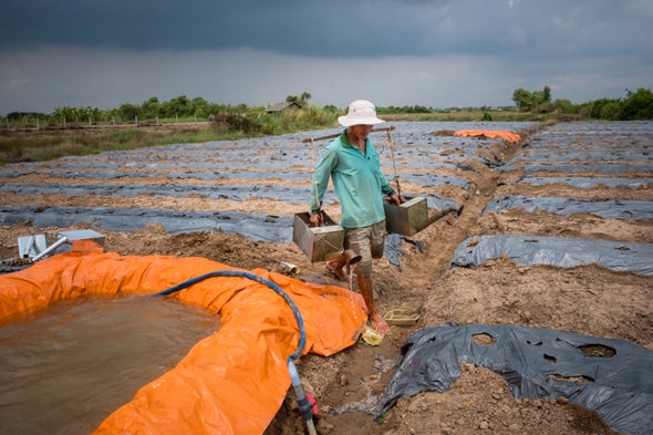
Unlike rocky continental coasts, deltas are made of soft, fertile river sediments deposited over thousands of years that can easily compact and subside. Subsidence can grow worse when upstream dams block the incoming flow of new sediments in rivers or when groundwater or natural gas is pumped up from below, removing underlying support for the land, which contracts like a drying sponge. Urban infrastructure and paved roads can also prevent groundwater from seeping into the land, recharging the aquifers. All these forces are at play in the Mekong, which is subsiding in some areas at rates approaching five centimeters per year—among the fastest in the world. According to Nguyen Hong Quan, a hydrogeologist at Vietnam National University, flooding has grown more common in both upper and coastal parts of the delta. Rivers and aquifers are also being contaminated by intruding seawater, which poisons protective wetlands and mangroves—and even coastal crops—from the roots up.
Warning signs have been evident for some time. Ten years ago, James Syvitski, an oceanographer at the University of Colorado Boulder who has since retired, published a landmark paper predicting that many of the world’s deltas could face catastrophic flooding in the 21st century. Syvitski based his widely publicized analysis on topography information gathered by the space shuttle Endeavour over an 11-day period in February 2000. Known as the Shuttle Radar Topography Mission (SRTM), this global survey was sponsored in part by the U.S. Department of Defense, which retained high-resolution data for military purposes and made a low-resolution data set freely available for civilian research.
SRTM information and, to a lesser extent, other space-based measurements of delta topography appear in numerous international assessments, which the World Bank and other groups rely on when making policy decisions, such as where to allocate resources for flood preparedness. Although the SRTM data led Syvitski to his insight, the measurements are prone to vertical errors ranging up to 10 meters or more. “Not so bad if you’re modeling the Himalayas,” Törnqvist says. “But for a low-lying delta, that’s a whole different story.”
The gold standard remote-sensing system used for measuring delta heights—lidar, which is often mounted on aircraft—can determine vertical elevations to within a few centimeters. But lidar is expensive and generally unavailable in developing countries.
SRTM data had put the Mekong’s average elevation at 2.6 meters. But Minderhoud, who was with a Dutch research team studying subsidence in the delta, was skeptical. He had used SRTM measurements to create three-dimensional maps of the delta’s hydrology, yet the resulting maps had strange elevation patterns that were not consistent with the local terrain. Minderhoud says his Vietnamese colleagues knew the government had been collecting ground-based survey data and even some lidar measurements. Vietnamese academics in the country, however, were barred by the government from publishing that information in international journals, according to Minderhoud.
Robert Nicholls, a coastal engineer at the University of Southampton in England, says it is not unusual for governments to withhold their own topography measures for national security reasons, citing Bangladesh and India as examples. Because those data can be used to support strategic military operations, such as troop movements that depend on knowing whether ground will be wet or dry, “they are not in the public domain,” Nicholls says. And governments may simply not want to stir drama among local populations, Törnqvist notes.
To gain access to the Vietnamese data, Minderhoud first had to build trust with government institutions and identify opportunities for cooperation. “I tried to find out how my own research might contribute to their goals,” he says. “The key was to make this a combined effort.” In time, he wound up with a data set of 20,000 elevation points measured throughout the delta, which he subsequently used to create a new digital map of its topography.
But Minderhoud and his colleagues also performed a crucial step that is frequently neglected in global and regional assessments: they calibrated the data to a local benchmark for zero elevation, specifically at an island town along Vietnam’s coast called Hon Dau. The calibration was necessary because ocean currents, temperature and other forces can cause water to “pile up” along certain local coastlines and estuaries, increasing sea-surface height in some areas more than others. The more typical approach is to use a global benchmark for zero elevation. But because global benchmarks may not reflect local sea-surface height, they can introduce further errors. In the Mekong, the ground-truthed elevation was lower than the SRTM measurement, a finding that Nguyen maintains “was not a surprise to scientists in Vietnam.” By combining average rates for sea-level rise and for subsidence, Minderhoud estimates that the delta will submerge by 0.8 meter on average in 57 years.
Minderhoud notes that discrepancies between local lidar and satellite measurements can work both ways: elevations could be higher than what the space-based observations indicate. “That’s why you have to model each delta individually,” he says. Heri Andreas, a researcher at the Bandung Institute of Technology in Indonesia, who was not involved in the new study, agrees. According to Andreas, Jakarta—coastal home to 10 million people and one of the fastest-sinking cities on earth—has been modeled extensively with lidar. It is estimated that much of the city’s northwest could be completely submerged by 2050, and residents living there may have to be evacuated to higher ground. With Jakarta subsiding into the Java Sea, Indonesian president Joko Widodo recently announced plans to build a new capital city on the island of Borneo. “But many other cities in Indonesia are also experiencing subsidence, and we don’t have accurate elevation models for most of them,” Andreas says. “That’s a significant problem for our mitigation programs—we don’t know how low the land really is or when it might be inundated.”
Nguyen says the Vietnamese government is developing what he claims is a new and even more precise elevation map. He says the government is also drawing up new plans to limit groundwater extraction and protect the coastal mangroves so they are not washed out to sea, allowing ocean rise to encroach inland unabated. As for relocating people, Nguyen says he is unaware of any plans to that effect. “The challenge is to convince people if the prediction is reliable enough to take action,” he says. “I feel the Mekong Delta is very beautiful, but in a dangerous place. We want to show the world how we’re working to defend it so it won’t disappear.”
ABOUT THE AUTHOR(S)


Đăng nhận xét